


When the Tampa Bay History journal was re-issued in 2007 (originally published from 1979-1998) the first essay in the edition was an intriguing look at the Tampa bypass canal system and flood management control in central Hillsborough County titled "The Taming of the Hillsborough River: How Tampa Gained a Moat, Destroyed a Creek, and Forgot a River" by Thom Foley. While the Hillsborough River is mentioned in the title, the essay focused mostly on Palm River and Six Mile Creek.
Palm River is south of SR 60 / Adamo Drive and flows into McKay bay south of Ybor City. Upstream the river bends towards the north and was called Six Mile Creek. Here was where Plant's railroad first entered the area. In the first half of the 20th century if you were traveling into Tampa from Brandon, Plant City, Lakeland or any other community to the East you had to travel down Broadway over an old bridge spanning Six Mile Creek. Surrounding the bridge was the small community of Six Mile Creek that contained a market and service station ready to meet the needs of travelers. When settlers first came to the area they set up farms along the creek and river. As the area grew industrial factories began to set up shop near the creek and river shores.


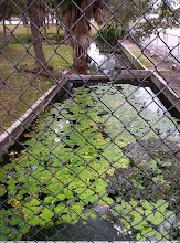
While Foley's article is titled to indicate that it is about the "taming of the Hillsborough River" it is really about the destruction of Palm River and Six Mile Creek, which were ultimately transformed into Canal 135 of the Tampa Bypass Canal system. In 1966 the first part of the canal started when dredging began between McKay Bay and the US41 / 50th street bridge. In 1968 a second contract was given for the portion of the canal to be dredged between the US41 / 50th Street bridge and SR60. However, in dredging the river in 2 phases, the area directly under the US41 bridge was never touched, leaving a berm that acted as a dam for sediment. The canal was finally finished by 1983. Today the Palm River is metaphorically buried, it's original flow path destroyed by canalization and it's waters poisoned by toxic runoff from factories that dotted its shores, malathion spraying and general polution. Out of 14 superfund sites located throughout Hillsborough County, eight are located less than 2 miles from Palm River's shores.

At the time of the essays publishing, SWFWMD had committed to looking at restoration of the river. I decided to follow up and see what had happened since 2007. After years of delays SWFWMD finally ordered a survey of the river's condition that was completed in February 2009. It found that the berm under the US 41 bridge was not as large as expected and that much more sediment had accumulated at the bottom of the river. As indicated in Foley's article a restoration project (W367) has been initiated by SWFWMD. As of February 2009 all data collection was completed, indicating that a smaller berm than anticipated is located under US41 and large amounts of sediment had accumulated in the river. Reports also indicate the Palm River has the highest salinity of any of the 4 tributaries that empty into Hillsborough and Tampa Bay. Plans for the restoration are still being formulated. However, construction is expected to commence this summer with restoration work completed by December 2012.
I read that Six-Mile Creek was previously known as Coller's Creek after Levi Coller who farmed in that area. http://www.tampapix.com/whatsinaname.htm
ReplyDeleteDo you know about six mile creek?
ReplyDeleteI would like to know more about the area
ReplyDeleteI've heard Winslow Homer painted one or more scenes of the Palm River, but I'm not finding any evidence online. Has anyone else heard that? Have a source?
ReplyDelete