Growing up in Brandon and Tampa I had always dreamed of moving away as soon as I was old enough. I only got as far away as Gainesville for college. As soon as I was done with school I moved right back in with my parents and started working in Tampa. I accepted my lot and started exploring more of the city, meeting new people, discovering new places and learning more about the history of the city. I could start to see how the city was changing. Around this time the real estate bubble was just beginning to inflate, empty lots were being built on and old buildings were being bought to make way for new. Some of these places I had remembered seeing or going to as a child, but my memory was fuzzy and I couldn't really see the building in my head. So I stumbled upon the Burgert Bros. Collection and started to browse through pictures of these places. I also discovered pictures of some amazing buildings and places that were gone by the time I was born. I become obsessed with placing these building and spaces on google maps. Sometimes I find that the building was still there but heavily modified. Sometimes I'd hope to find a trace of something, a tangible link to the past. Four years ago I started making a map to highlight my finds. More after the jump...
View Historical Tampa in a larger map
Thursday, June 23, 2011

Tuesday, May 17, 2011
Things are changing on Bayshore
Out jogging last night and caught these huge monsters laying in wait around Rome and Bayshore. It made me wonder if the city is adding another traffic signal, perhaps at Rome and Bayshore, although the work descriptions only note upgrades to existing traffic signals.


The City of Tampa's website describes the work as this:
St. Pete Times articlePhase I of the project will provide for continuous 4 foot bicycle lanes in both directions along Bayshore Boulevard between Platt Street to Rome Avenue. The existing 4-lane roadway, between Platt Street and the Davis Island Bridge, will be modified to provide 4 foot continuous bicycle lanes and a concrete median. The existing 6-lane roadway, between the Davis Island Bridge and Rome Avenue will be modified to a 4-lane roadway with a 14 foot grassed median and 4 foot bike lanes. The project will also include upgrading the existing traffic signals and enhanced pedestrian features at the intersections of Bay-to-Bay Boulevard and Platt Street. These enhancements will provide for improved safety for pedestrians and bicyclists that utilize Bayshore Boulevard.
Sunday, May 15, 2011
National Train Day post HSR

Saturday, May 7th was the 4th Annual National Train Day event at Tampa Union Station, so I ventured out for the first time. The station was abuzz with young kids and older train enthusiasts(both model and regular sized), and also May 21st Doomsdayers!?

Falling somewhere in middle of the 15-65 category, and not toting around one of the former, I admit I felt a little out of place so I strolled through as quickly and quietly as possible. I went with camera in tow hoping to capture some amazing train architecture and infrastructure (accomplished - see pictures below). I also was hoping to catch someone with some information on the future of the state's high speed rail plans (nothing). As if the current news of Florida's HSR dollars finally being offered to other projects around the country wasn't enough (see here and here), it seems that FLHSR has given up fully as their website is currently down.

Saturday, April 23, 2011
Digitized Historic Aerial Photo Collection
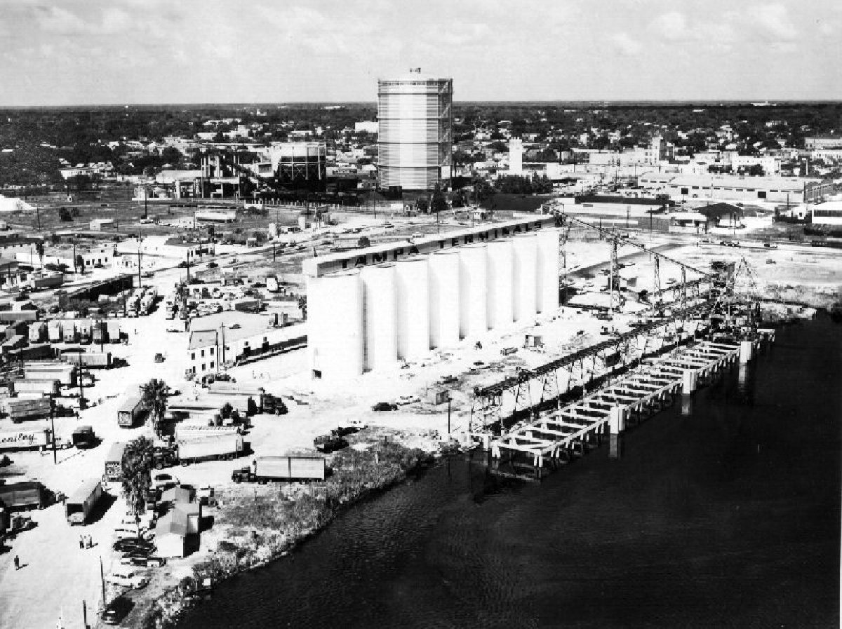 |
| TampaTerminal on the Ybor Channel looking North, Northeast towards the Tampa Gas Company storage tank (1956) |
Somehow while searching for historic pictures I came across a collection of historic aerial photographs digitized by the University of South Florida that I had never seen before, The Graber Collection of Florida Aerial Photographs. The USF website for the collection states:
"As early as 1949, Robert Graber and his company, Airflite Aerial Photographers, began photographing the growth of Florida's west coast. By the time Graber stopped taking aerial photographs in 1990, the St. Petersburg photographer had accumulated approximately 27,000 aerial shots, many of which are presented here.The Graber Collection of Aerial Photography consists of more than 8,000 individual photographic negatives spanning 1949-1990. The photographs are dated and indexed according to the records of the original photographer; logbooks provide additional information about many of the aerial shots. Most of the photographs, which were taken by Graber with a K-24 military surveillance camera, document land development and construction on Florida's west coast. The collection was donated by Ken and JoAnne Taylor in 1997. There are 4,781 images online from the years 1956-1959."
While most of the photographs available online seem to be of development along the Pinellas beaches and in Pinellas county, there are some great shots of Tampa and development taking place there during 1956-1959. Many are shots from angles I am not use to seeing or of areas that didn't get a lot of attention from the Burgert's. Please keep in mind that most of the photos are low resolution or low quality. Below are some highlights:
 |
| Railroad tracks through Hyde Park and Dobyville are looking Southwest centered over Platt and Dakota (1957) |
Tuesday, April 19, 2011
Tampania Tweets
I am starting a twitter feed for Tampania. While I hope it will prove to be a good platform for short bursts of creativity and thinking, ruminations on the Tampa landscape, and news. I am sure there will also be a lot of relevant re-tweets. So follow me if you tweet and maybe I'll do the same to you.
 |
| Long distance switch operators at Peninsular Telephone, Tampa (1948) Burgert Bros. |
Friday, March 25, 2011
Tunnel Under the Bridge Downtown NOW OPEN


Saturday, January 22, 2011
Ghosts of the garrison
It was a lovely day for a bike ride, so I headed for downtown. It was still a little too chilly in the shadows of the downtown skyscrapers so I pedaled over towards the parking wasteland of South downtown. I'm always fascinated when I travel through this area at how the bodies of the buildings that once dotted this area are still visible. Most the buildings were knocked down only to their foundations.
Sometimes a foot or two of wall was left to serve as a type of barrier between the street and lot.


Sometimes a foot or two of wall was left to serve as a type of barrier between the street and lot.


Subscribe to:
Posts (Atom)