A visually and cartographically explicit narrative blog about Tampa's built history and development.
(Above banner created from photo in the Burgert Brothers Photographic Collection)


Monday, April 19, 2010

Burying our Past - Palm River


When the Tampa Bay History journal was re-issued in 2007 (originally published from 1979-1998) the first essay in the edition was an intriguing look at the Tampa bypass canal system and flood management control in central Hillsborough County titled "The Taming of the Hillsborough River: How Tampa Gained a Moat, Destroyed a Creek, and Forgot a River" by Thom Foley.   While the Hillsborough River is mentioned in the title, the essay focused mostly on Palm River and Six Mile Creek.

Palm River is south of SR 60 / Adamo Drive and flows into McKay bay south of Ybor City.  Upstream the river bends towards the north and was called Six Mile Creek.  Here was where Plant's railroad first entered the area.  In the first half of the 20th century if you were traveling into Tampa from Brandon, Plant City, Lakeland or any other community to the East you had to travel down Broadway over an old bridge spanning Six Mile Creek. Surrounding the bridge was the small community of Six Mile Creek that contained a market and service station ready to meet the needs of travelers.  When settlers first came to the area they set up farms along the creek and river.  As the area grew industrial factories began to set up shop near the creek and river shores.

Tuesday, April 13, 2010

Burying our Past - Spanishtown Creek

The first recorded non-native settlement in Tampa was at Spanishtown Creek.  It was said to be inhabited by Cuban fishermen around 1783, many decades before Fort Brooke was established.  Up until the establishment of Henry Plant's railway and hotel in the late 1880s this area was mainly farmland and homesteads.  After Plant's hotel was built tony neighborhoods began to platted directly south of the hotel, centering along Hyde Park Ave. (named after Chicago's Hyde Park neighborhood) and Plant Ave.  Slowly this area started to become more developed.  Below is the original plat map of the Packwoods Subdivision from 1892, from the Hills. Co. Property Appraisers site which shows the path of the creek at that time and how the lots and streets would be laid out:


Wednesday, April 7, 2010

South Franklin Street demolition "breaking news"

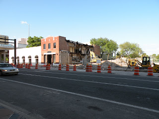
On South Franklin Street across from the Convention Center there is a row of old buildings that are the last testament of the bustling warehousing and manufacturing center that lined  the waterfront South of downtown.   Recently work commenced on the TECO Streetcar line extension and a few months ago the 2 story building at 238 S. Franklin (The former Fuel teen nightclub) was demolished. You would think that the 2 events were related.  You can see the block below in the birdseye view.   

Then, a friend called me today to say that another building on South Franklin Street across from the convention center was coming down.  Here is the picture I took this afternoon.

Monday, April 5, 2010

Burying our Past - Palma Ceia Springs

Urban springs are fascinating to me. In Florida, springs usually seem to be billed as "natural destinations" in rural and smaller towns, off the beaten path, or the source for our bottled water needs.  There are a few intact springs within the Tampa City limits.  However, most of these springs have been covered over and made part of a greater underground stormwater drainage system.  One of these is Palma Ceia springs right off Bayshore Blvd. and Rubideaux in Fred Ball Park.

Palma Ceia Spring


In the mid 1800s this spring was known for it's healing powers and people came to bathe in its waters. This fountain was erected in 1906 (as the inscription on both sides indicates) and is supplied by the spring itself. one of the few indications that an actual spring lies somewhere underfoot.  A large pool was erected in 1928 to accomodate the growing population and number of tourists coming to the area.